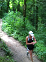
Summary: The Lafayette-Moraga Trail is a paved bike path that starts in Lafayette and goes up to Moraga. It is very scenic and there is usually a bit of shade on the trail, at least in the first few miles. I swear the people up here are the nicest in the bay area and you'll get lots of "Good Morning"s from them. It's a little hilly, and I've had a couple really rough runs before from pushing too hard on the initial gradual climb. Take it easy and enjoy the scenery. There are mile markings on the path in paint. The trail is easy to follow, but watch the signs after mile 6, you'll take a little jog down Country Club Drive before picking up the trail again.
Gmap: http://www.gmap-pedometer.com/?r=2209082
Related blog posts: http://runningstories.blogspot.com/2007/09/long-run-week-1-humble-me-lord.html http://runningstories.blogspot.com/search?q=victory+is+mine
Distance: 15 miles (max)
Conditions: Paved path with dirt shoulder
Profile: Gradual climb for the first 5 miles, up to St. Mary's College. Some of the last hills before the top are a bit steeper. Then you go down for a couple miles, where it eventually flattens out. You get the opposite on the way back of course.
Start/Park: Parking lot at Pleasant Hill Rd./Olympic Blvd. (no fee) Trail heads out the west side of the parking lot. The official "start" of the trail is about 0.2 mile past Reliz Station Rd.
Water: There is a drinking fountain just before the 1 mile mark. There is another but I don't know exactly where. Then, there is a park at mile 5.75, just before the crosswalk at Moraga Rd. This park (Moraga Commons) has drinking fountains and restrooms. You pass a Safeway at about mile 6 where you could buy water or snacks.
Breakfast: Chow (58 Lafayette Circle) or Noah's (3518 Mt. Diablo Blvd.)